

As is most of central Texas, the hydrology on the Browning Ranch depends on rainfall making it way into porous limestone. Standing in the way is the vegetation, steep slopes, and scorching summers that either consume or wash away the rain before it gets a chance to infiltrate the stone. Rain that reaches the limestone is temporarily stored in cavities and cracks within the rock, eventually emerging through a seep or spring.
The Browning Ranch rests inside the 1,240-acre Honeycut Hollow Creek watershed. The watershed drains from the south to the north, directly into the Pedernales River. The highest elevation in this watershed is a hilltop in the southwest corner that rises 1,300 feet above mean sea level. From there the watershed drains down 320 feet in elevation until it meets the Pedernales River at 980 feet above mean sea level.
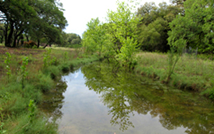
Honeycut Hollow Creek downstream from Honeycut Hollow Spring.
As Honeycut Hollow Creek continued to cut deeper into the rock layers, a spring was eventually exposed three-quarters of a mile from the river’s edge. Called Honeycut Hollow Spring, it flows year-round and provides a reliable source of clean water for the ranch. Baseline measurements indicate that this spring is very consistent in flow and temperature and supports a stable community of aquatic organisms.